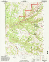
1993 Map of Old Maid Gulch
USGS Topo · Published 1997About this map
Bighorn National Forest dominates this landscape, where the dramatic descent of the Tensleep Canyon carves through the central terrain. This 1990s revision reveals a geography defined by its transitions from high mountain draws to broad plateaus like Schoonover Flats. Human presence is anchored by the Tensleep Fish Hatchery and local landmarks like the Leigh Monument and Circle J Ranch. The map details specialized land use, including the Girl Scout National Center West Boundary and the infrastructure of the Cloud Peak Skyway Scenic Byway. These transport corridors, such as Rome Hill Road, follow the natural contours of the drainages, connecting remote outposts like Canyon Lodge and the historical site of Williams Mill to the wider region. The intricate network of springs and gulches, including Old Maid Gulch and Cooks Canyon, illustrates the complex hydrology of the western Bighorns.
Find a feature on this map
44 named features on this map. Tap any name to fly to it.
Don’t see what you’re looking for? This feature index may not catch every label — zoom into the map to look around manually.
Map Details
Editions of this 1993 Old Maid Gulch Map
This is the sole edition of this map. No revisions or reprints were ever made.
Other maps of this area

1899 · Cloud peak
USGS Topo · 1:125,000

1901 · Cloud Peak
USGS Topo · 1:125,000

1955 · Sheridan
USGS Topo · 1:250,000

1955 · Arminto
USGS Topo · 1:250,000

1958 · Sheridan
USGS Topo · 1:250,000

1958 · Arminto
USGS Topo · 1:250,000

1962 · Sheridan
USGS Topo · 1:250,000

1962 · Arminto
USGS Topo · 1:250,000

1966 · Monument Hill
USGS Topo · 1:24,000

1966 · Big Trails NE
USGS Topo · 1:24,000