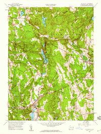
1958 Map of Old Mystic
USGS Topo · Published 1959About this map
Old Mystic serves as the focal point for this late 1950s survey, situated along the upper reaches of the Mystic River where the boundaries of Stonington, Groton, and Ledyard converge. The landscape is a mosaic of dense woodlands and numerous small water bodies, including Long Pond and the Lake of Isles. Significant land use patterns are visible, particularly the Pequot Indian Reservation and the Pequot Indian Reservation Eastern Tribe, illustrating the enduring presence of indigenous landholdings in New London County.
Find a feature on this map
60 named features on this map. Tap any name to fly to it.
Don’t see what you’re looking for? This feature index may not catch every label — zoom into the map to look around manually.
Map Details
Editions of this 1958 Old Mystic Map
2 editions found
Other maps of this area

1889 · Stonington
USGS Topo · 1:62,500

1889 · Moosup
USGS Topo · 1:62,500

1892 · New London
USGS Topo · 1:62,500

1892 · Norwich
USGS Topo · 1:62,500

1893 · Moosup
USGS Topo · 1:62,500

1893 · Stonington
USGS Topo · 1:62,500

1893 · New London
USGS Topo · 1:62,500

1920 · Moosup
USGS Topo · 1:62,500

1921 · New London
USGS Topo · 1:62,500

1921 · Stonington
USGS Topo · 1:62,500