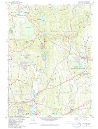
1983 Map of Old Mystic
USGS Topo · Published 1984About this map
The Mystic River forms a focal point for this area of New London County, as the village of Old Mystic sits near its northern reaches just above Burnetts Corner. The landscape reflects a mix of tribal heritage and colonial-era settlement, anchored by the Pequot Indian Reservation and the Pequot Indian Reservation Eastern Tribe. Historic family ties are preserved through numerous burial sites, including the Mashantucket Burial Ground and several small plots like Gallup Cem and Whitehall Cem. Much of the eastern terrain is dedicated to conservation, from the Assekonk Swamp Wildlife Management Area to the edges of Pachaug State Forest. The local economy at this time remained tied to the earth, indicated by the Quarry near Lantern Hill and several active Sand and Gravel Pits scattered across the surrounding hills.
Find a feature on this map
88 named features on this map. Tap any name to fly to it.
Don’t see what you’re looking for? This feature index may not catch every label — zoom into the map to look around manually.
Map Details
Editions of this 1983 Old Mystic Map
3 editions found
Other maps of this area

1889 · Stonington
USGS Topo · 1:62,500

1889 · Moosup
USGS Topo · 1:62,500

1892 · New London
USGS Topo · 1:62,500

1892 · Norwich
USGS Topo · 1:62,500

1893 · Moosup
USGS Topo · 1:62,500

1893 · Stonington
USGS Topo · 1:62,500

1893 · New London
USGS Topo · 1:62,500

1920 · Moosup
USGS Topo · 1:62,500

1921 · New London
USGS Topo · 1:62,500

1921 · Stonington
USGS Topo · 1:62,500