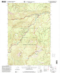
2000 Map of Old Scab Mountain
USGS Topo · Published 2001About this map
Old Scab Mountain and Little Bald Mountain define the high terrain of this portion of the Wenatchee National Forest, as revised by the Forest Service at the turn of the millennium. The landscape is a network of drainage basins including Bumping River, Nile Creek, and Scab Creek, punctuated by recreation sites like Soda Springs Campground and Cedar Springs Campground. The map shows a transition from managed forest lands to protected wilderness areas such as the William O Douglas Wilderness and Douglas American Wilderness. Of particular interest to researchers are the detailed trail systems, including National Forest Trail 384 and National Forest Trail 350, which navigate the complex ridges and basins. Local infrastructure is represented by a Gaging Sta on the river and a Lookout on Little Bald Mountain, reflecting the area's history of resource monitoring and fire watch.
Find a feature on this map
77 named features on this map. Tap any name to fly to it.
Don’t see what you’re looking for? This feature index may not catch every label — zoom into the map to look around manually.
Map Details
Editions of this 2000 Old Scab Mountain Map
This is the sole edition of this map. No revisions or reprints were ever made.
Other maps of this area

1901 · Snoqualmie Pass
USGS Topo · 1:125,000

1902 · Mount Aix
USGS Topo · 1:125,000

1903 · Snoqualmie
USGS Topo · 1:125,000

1904 · Mt Aix
USGS Topo · 1:125,000

1950 · Yakima
USGS Topo · 1:250,000

1957 · Wenatchee
USGS Topo · 1:250,000

1958 · Yakima
USGS Topo · 1:250,000

1961 · Yakima
USGS Topo · 1:250,000

1961 · Easton
USGS Topo · 1:62,500

1962 · Bumping Lake
USGS Topo · 1:62,500