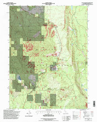
1995 Map of Old Station
USGS Topo · Published 1998About this map
Lassen National Forest terrain dominates this 1990s survey, illustrating a landscape defined by volcanic activity and public land management. The small community of Old Station serves as a central hub, situated near the Old Station (PO) Trailer Park and supporting various administrative facilities including a Work Center, Water Treatment Plant, and a Heliport. The presence of a Gaging Station and Footbridge along Hat Creek points to the area's importance for water monitoring and recreation.
Find a feature on this map
35 named features on this map. Tap any name to fly to it.
Don’t see what you’re looking for? This feature index may not catch every label — zoom into the map to look around manually.
Map Details
Editions of this 1995 Old Station Map
This is the sole edition of this map. No revisions or reprints were ever made.
Other maps of this area

1886 · Lassen Peak
USGS Topo · 1:250,000

1892 · Lassen Peak
USGS Topo · 1:250,000

1894 · Lassen Peak
USGS Topo · 1:250,000

1935 · Burney
USGS Topo · 1:96,000

1939 · Burney
USGS Topo · 1:125,000

1939 · Halls Flat
USGS Topo · 1:125,000

1955 · Westwood
USGS Topo · 1:250,000

1956 · Manzanita Lake
USGS Topo · 1:62,500

1957 · Prospect Peak
USGS Topo · 1:62,500

1957 · Burney
USGS Topo · 1:62,500