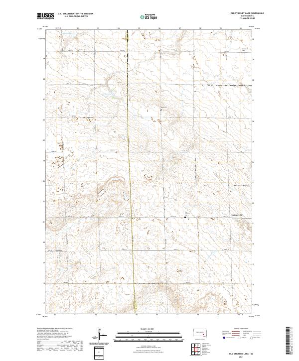
2021 Map of Old Stickney Lake
USGS Topo · Published 2021About this map
The boundary of Aurora Co and Davison Co runs through this landscape of the South Dakota plains. In the early 21st century, this area of Davison County is characterized by its organized section-line road grid, including 260th St and 393rd Ave, which structure the rural landscape. Water bodies like Stickney Lake and Old Stickney Lake provide natural focal points in a region otherwise dominated by agricultural partitions and the seasonal flow of Twelvemile Cr. The settlement at Metzgerville and several scattered cemeteries, including the Union Cem and Nicolaisen Cem, mark the enduring sites of local heritage. The presence of Zion Lutheran Cem reflects the cultural and religious foundations of the community in this part of the Dakotas.
Find a feature on this map
29 named features on this map. Tap any name to fly to it.
Don’t see what you’re looking for? This feature index may not catch every label — zoom into the map to look around manually.
Map Details
Editions of this 2021 Old Stickney Lake Map
This is the sole edition of this map. No revisions or reprints were ever made.
Other maps of this area

1899 · Mitchell
USGS Topo · 1:125,000

1955 · Mitchell
USGS Topo · 1:250,000

1959 · Mitchell
USGS Topo · 1:250,000
1979 · Hillside
USGS Topo · 1:24,000

1980 · Stickney
USGS Topo · 1:24,000

1980 · Corsica Lake
USGS Topo · 1:24,000

1980 · Old Stickney Lake
USGS Topo · 1:24,000
1980 · Mitchell SW
USGS Topo · 1:24,000

1980 · Mount Vernon
USGS Topo · 1:24,000
1980 · Betts
USGS Topo · 1:24,000