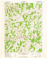
1962 Map of Old Washington
USGS Topo · Published 1963About this map
The Salt Fork Wildlife Area dominates the northern reaches of this Guernsey County landscape, where the waters of Salt Fork and Brushy Fork converge amidst a network of rural townships. The village of Old Washington serves as a central hub, situated near a Fairground and the small settlements of Easton and Elizabethtown. This era of mapping documents the early alignment of a Proposed highway, which would eventually transform local travel by bypassing the traditional centers of Warrentown and Winterset. Genealogists will find several burial grounds identified, including Winterset Cem, Glenview Cem, and Allen Cem. The presence of the County Home and Madison High Sch reflects the social and educational infrastructure of the mid-century period. Notable terrain features like Devils Knob punctuate the ridges above the many named runs, such as Coon Run and Beeham Run, that drain this agricultural and wooded terrain.
Find a feature on this map
27 named features on this map. Tap any name to fly to it.
Don’t see what you’re looking for? This feature index may not catch every label — zoom into the map to look around manually.
Map Details
Editions of this 1962 Old Washington Map
3 editions found
Other maps of this area

1909 · Antrim
USGS Topo · 1:48,000

1909 · Summerfield
USGS Topo · 1:62,500

1909 · Cambridge
USGS Topo · 1:62,500

1911 · Antrim
USGS Topo · 1:62,500

1911 · Cumberland
USGS Topo · 1:62,500

1911 · Summerfield
USGS Topo · 1:62,500

1912 · Cambridge
USGS Topo · 1:62,500

1949 · Clarksburg
USGS Topo · 1:250,000

1951 · Canton
USGS Topo · 1:250,000

1953 · Canton
USGS Topo · 1:250,000