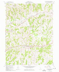
1962 Map of Old Washington
USGS Topo · Published 1974About this map
Old Washington serves as the primary hub of this eastern Ohio landscape, shown here just as the modern interstate system was being planned across Center and Wills townships. The map documents a rural corridor transitioning between traditional farming and new infrastructure, marked by the clear designation of a Proposed highway route that would eventually bisect the region. To the north, the Salt Fork Wildlife Area and Devils Knob define the more rugged terrain, while local life centers on small communities like Winterset and Warrentown. Genealogists will find significant value in the documentation of several family and community burial grounds, including Winterset Cem, Glenview Cem, and Allen Cem, alongside landmarks like the Fairground and Madison High Sch. The intricate drainage system of Salt Fork and its tributaries, such as Coon Run and Infirmary Run, illustrates the local topography before major hydrological changes.
Find a feature on this map
29 named features on this map. Tap any name to fly to it.
Don’t see what you’re looking for? This feature index may not catch every label — zoom into the map to look around manually.
Map Details
Editions of this 1962 Old Washington Map
3 editions found
Other maps of this area

1909 · Antrim
USGS Topo · 1:48,000

1909 · Summerfield
USGS Topo · 1:62,500

1909 · Cambridge
USGS Topo · 1:62,500

1911 · Antrim
USGS Topo · 1:62,500

1911 · Cumberland
USGS Topo · 1:62,500

1911 · Summerfield
USGS Topo · 1:62,500

1912 · Cambridge
USGS Topo · 1:62,500

1949 · Clarksburg
USGS Topo · 1:250,000

1951 · Canton
USGS Topo · 1:250,000

1953 · Canton
USGS Topo · 1:250,000