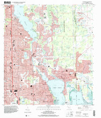
1995 Map of Oldsmar
USGS Topo · Published 2000About this map
Lake Tarpon and the northern reaches of Safety Harbor dominate this coastal landscape at the mid-1990s boundary of Pinellas and Hillsborough counties. The planned street grids of Oldsmar and Safety Harbor are well established, showing significant suburban density alongside specialized infrastructure like the Florida Downs Racetrack. To the north, the massive Brooker Creek County Preserve and Bccp lands stand in contrast to the rapid residential development of Harbor Palms and Innisbrook. Notable cultural markers include the Espiritu Santo Ch and an Indian Mound near Philippe Pt, suggesting a long history of human habitation on the peninsula. The map captures a transitional moment where remaining citrus groves and pastures were being replaced by extensive golf courses and community parks such as John Chestnut Senior County Park.
Find a feature on this map
71 named features on this map. Tap any name to fly to it.
Don’t see what you’re looking for? This feature index may not catch every label — zoom into the map to look around manually.
Map Details
Editions of this 1995 Oldsmar Map
This is the sole edition of this map. No revisions or reprints were ever made.
Other maps of this area

1921 · Sand Key
USGS Topo · 1:62,500

1921 · St Petersburg
USGS Topo · 1:62,500

1943 · Gandy Bridge
USGS Topo · 1:31,680

1943 · Safety Harbor
USGS Topo · 1:31,680

1943 · Dunedin
USGS Topo · 1:31,680

1943 · Tarpon Springs
USGS Topo · 1:31,680

1943 · Clearwater
USGS Topo · 1:24,000

1943 · Odessa
USGS Topo · 1:24,000

1943 · Elfers
USGS Topo · 1:24,000

1943 · Oldsmar
USGS Topo · 1:24,000