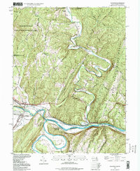
1998 Map of Oldtown
USGS Topo · Published 1999About this map
The Potomac River carves a deep, winding path through this corner of the Appalachian landscape, where the historic Chesapeake and Ohio Canal and the B & O Railroad converge at the settlement of Oldtown. This map documents a critical transportation corridor at the Maryland and West Virginia border, showing the dense network of rails and river navigation that once powered the region's economy. The topography is dominated by the massive ridge lines of Warrior Mountain and Town Hill, which hem in the fertile valley flats of Town Creek.
Find a feature on this map
52 named features on this map. Tap any name to fly to it.
Don’t see what you’re looking for? This feature index may not catch every label — zoom into the map to look around manually.
Map Details
Editions of this 1998 Oldtown Map
This is the sole edition of this map. No revisions or reprints were ever made.
Other maps of this area

1891 · Romney
USGS Topo · 1:125,000

1894 · Winchester
USGS Topo · 1:125,000

1898 · Paw Paw
USGS Topo · 1:62,500

1899 · Flintstone
USGS Topo · 1:62,500

1900 · Pawpaw
USGS Topo · 1:62,500

1900 · Flintstone
USGS Topo · 1:62,500

1910 · Paw Paw
USGS Topo · 1:62,500

1916 · Capon Bridge
USGS Topo · 1:62,500

1921 · Hanging Rock
USGS Topo · 1:48,000

1923 · Capon Bridge
USGS Topo · 1:62,500