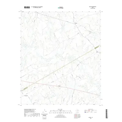
2019 Map of Oletha
USGS Topo · Published 2019About this map
Headsville and Oletha sit at the intersection of rural ranching and creek-fed bottomlands along the border of Limestone and Robertson counties. This landscape is defined by the winding course of Steele Cr, which dominates the central drainage, joined by tributaries such as Owens Cr, Cox Cr, and Heads Cr. The region's history is preserved in small, scattered family and community burial grounds, including Ebenezer Cem near the southwestern corner and Ferguson Cem to the northeast. Transportation follows a network of farm-to-market roads like FM 1246 and FM 937, while more remote reaches are accessed via cattle-guard entries and routes such as Oil Well Rd and M Ranch Rd. The inclusion of the RMR Ranch Airport reflects the continued importance of large-scale landholdings in this part of East Central Texas, where the topography transitions from the elevations of Wolf Hollow down toward the wet prairie of the Willow Cr basin.
Find a feature on this map
48 named features on this map. Tap any name to fly to it.
Don’t see what you’re looking for? This feature index may not catch every label — zoom into the map to look around manually.
Map Details
Editions of this 2019 Oletha Map
This is the sole edition of this map. No revisions or reprints were ever made.
Other maps of this area

1925 · Marquez No. 1
USGS Topo · 1:48,000

1927 · Marquez
USGS Topo · 1:62,500

1930 · Marquez
USGS Topo · 1:62,500

1954 · Waco
USGS Topo · 1:250,000

1955 · Waco
USGS Topo · 1:250,000

1962 · Petteway
USGS Topo · 1:24,000
1965 · Marquez
USGS Topo · 1:24,000
1965 · Bald Prairie
USGS Topo · 1:24,000
1966 · Round Prairie
USGS Topo · 1:24,000

1966 · Thornton
USGS Topo · 1:24,000