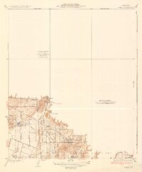
1935 Map of Olinda
USGS Topo · Published 1935About this map
Yorba Linda and Placentia anchor this mid-1930s landscape, illustrating a period of transition as citrus groves and agricultural settlements began to interface with early infrastructure. The map reveals a complex water management system essential to the region's growth, featuring the Anaheim Union Canal and Anaheim Union Reservoir, alongside the Yorba Linda Reservoir. Transportation is defined by the heavy presence of the Atchison Topeka and Santa Fe and Pacific Electric lines, which supported both local transit and the movement of goods from smaller rail stops like Loftus, Daum, and Carlton. In the north, Olinda sits at the edge of the hills, while the broad Cajon De Santa Ana dominates the southwestern terrain, marked by a meticulous grid of named streets including Valencia Ave and Carolina Ave.
Find a feature on this map
22 named features on this map. Tap any name to fly to it.
Don’t see what you’re looking for? This feature index may not catch every label — zoom into the map to look around manually.
Map Details
Editions of this 1935 Olinda Map
This is the sole edition of this map. No revisions or reprints were ever made.
Other maps of this area

1894 · Pomona
USGS Topo · 1:62,500

1896 · Anaheim
USGS Topo · 1:62,500

1897 · Pomona
USGS Topo · 1:62,500

1897 · Cucamonga
USGS Topo · 1:62,500

1898 · Pomona
USGS Topo · 1:62,500

1898 · Anaheim
USGS Topo · 1:62,500

1900 · Cucamonga
USGS Topo · 1:62,500

1901 · Southern California Sheet No. 1
USGS Topo · 1:250,000

1901 · Anaheim
USGS Topo · 1:62,500

1902 · Corona
USGS Topo · 1:125,000