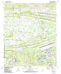
1987 Map of Olmstead
USGS Topo · Published 1987About this map
Little Rock Air Force Base dominates the southeastern corner of this Pulaski County landscape, situated just north of Jacksonville. The area is characterized by a transition from the higher elevations of Billy Goat Hill and Backbone Ridge in the north to the low-lying drainage basins of Cypress Bayou and Meto Bayou in the south. The agricultural and rural residential character of the mid-1980s is evident in the numerous small communities like Olmstead, Warsaw, and Gibson, each anchored by local landmarks such as Tates Mill or the Harmony Ch.
Find a feature on this map
82 named features on this map. Tap any name to fly to it.
Don’t see what you’re looking for? This feature index may not catch every label — zoom into the map to look around manually.
Map Details
Editions of this 1987 Olmstead Map
2 editions found
Other maps of this area

1891 · Little Rock
USGS Topo · 1:125,000

1893 · Little Rock
USGS Topo · 1:125,000

1935 · Mc Almont
USGS Topo · 1:24,000

1935 · North Little Rock
USGS Topo · 1:24,000

1941 · Olmstead
USGS Topo · 1:31,680

1941 · Cabot
USGS Topo · 1:31,680

1943 · Jacksonville
USGS Topo · 1:31,680

1953 · Cato
USGS Topo · 1:24,000

1954 · Mc Almont
USGS Topo · 1:24,000

1954 · Olmstead
USGS Topo · 1:24,000