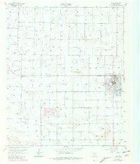
1963 Map of Olton
USGS Topo · Published 1981About this map
The town of Olton serves as the focal point of this agricultural landscape in the Texas Panhandle, as documented in 1963 with updates from 1979. The surrounding terrain is characterized by a dense network of water wells and storage basins, illustrating the intensive irrigation required for farming in Lamb County. To the west, the small settlement of Circle sits at a highway junction, while the presence of a massive Feedlot and a Pipeline cutting across the northwest corner highlights the area's industrial agricultural and energy infrastructure. Local social life and entertainment during this period are represented by the Olton Country Club, a Drive-in Theater, and a Drag Strip on the eastern edge of town. For those researching local history, the map provides precise locations for the High Sch and various municipal structures that defined the community mid-century.
Find a feature on this map
8 named features on this map. Tap any name to fly to it.
Don’t see what you’re looking for? This feature index may not catch every label — zoom into the map to look around manually.
Map Details
Editions of this 1963 Olton Map
2 editions found
Other maps of this area

1954 · Clovis
USGS Topo · 1:250,000

1958 · Clovis
USGS Topo · 1:250,000

1962 · Cofferville
USGS Topo · 1:24,000

1962 · Springlake
USGS Topo · 1:24,000

1962 · Fieldton
USGS Topo · 1:24,000

1963 · Olton
USGS Topo · 1:24,000

1963 · Dodd SE
USGS Topo · 1:24,000

1963 · Hart SW
USGS Topo · 1:24,000

1965 · Hilburn
USGS Topo · 1:24,000
1968 · Corry
USGS Topo · 1:24,000