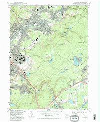
1994 Map of Olyphant
USGS Topo · Published 1996About this map
The Lackawanna River corridor anchors a dense network of boroughs and industrial infrastructure in this mid-1990s perspective of northeastern Pennsylvania. Communities like Olyphant, Dickson City, Jessup, and Dunmore form a continuous settlement pattern along the valley floor, linked by the Conrail lines and the Roosevelt Highway. The landscape is heavily marked by its coal-mining heritage, with numerous Quarry sites and features like Grassy Island and Grassy Island Creek appearing alongside modern developments.
Find a feature on this map
87 named features on this map. Tap any name to fly to it.
Don’t see what you’re looking for? This feature index may not catch every label — zoom into the map to look around manually.
Map Details
Editions of this 1994 Olyphant Map
This is the sole edition of this map. No revisions or reprints were ever made.
Other maps of this area

1889 · Scranton
USGS Topo · 1:62,500

1891 · Scranton
USGS Topo · 1:62,500

1892 · Honesdale
USGS Topo · 1:62,500

1892 · Dundaff
USGS Topo · 1:62,500

1893 · Scranton
USGS Topo · 1:62,500

1928 · Ariel
USGS Topo · 1:62,500

1932 · Ariel
USGS Topo · 1:62,500

1943 · Scranton
USGS Topo · 1:125,000

1943 · Honesdale
USGS Topo · 1:125,000

1946 · Dalton
USGS Topo · 1:24,000