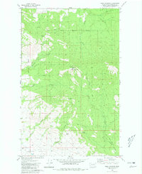
1980 Map of Omak Mountain
USGS Topo · Published 1981About this map
The Colville Indian Reservation Boundary divides this landscape, where the high peaks of Omak Mountain and Van Brunt Mtn dominate the northern terrain. This area in Okanogan County reflects a high-country environment defined by its water sources and drainage systems, including Wanacut Creek, Mill Creek, and the winding Tunk Creek. To the south, the terrain descends toward French Valley and the small settlement of Haley.
Find a feature on this map
22 named features on this map. Tap any name to fly to it.
Don’t see what you’re looking for? This feature index may not catch every label — zoom into the map to look around manually.
Map Details
Editions of this 1980 Omak Mountain Map
This is the sole edition of this map. No revisions or reprints were ever made.
Other maps of this area

1902 · Osoyoos
USGS Topo · 1:125,000

1904 · Osoyoos
USGS Topo · 1:125,000

1952 · Disautel
USGS Topo · 1:62,500

1953 · Omak Lake
USGS Topo · 1:62,500

1954 · Okanogan
USGS Topo · 1:250,000

1957 · Tonasket
USGS Topo · 1:62,500

1957 · Aeneas Valley
USGS Topo · 1:62,500

1958 · Okanogan
USGS Topo · 1:250,000
1980 · Camp Seven
USGS Topo · 1:24,000
1980 · Keystone
USGS Topo · 1:24,000