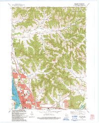
1993 Map of Onalaska
USGS Topo · Published 1993About this map
Onalaska Lake and the confluence of the Black River and La Crosse River anchor this early 1990s portrait of western Wisconsin. The city of Onalaska shows significant suburban expansion, evidenced by the concentration of institutional landmarks like Luther High Sch, Northern Hills Sch, and St Patricks Sch. Beyond the residential core, the landscape transitions into the distinctive coulee geography of the Driftless Area, where narrow valleys like Johnson Coulee and Sweden Coulee are separated by high ridges such as Camel Hump. The map documents a blend of conservation and infrastructure, from the Super Mississippi River National Wild Life and Fish Refuge along the western marshes to the recreational utility of the La Crosse River State Trail following the river corridor near Medary.
Find a feature on this map
55 named features on this map. Tap any name to fly to it.
Don’t see what you’re looking for? This feature index may not catch every label — zoom into the map to look around manually.
Map Details
Editions of this 1993 Onalaska Map
This is the sole edition of this map. No revisions or reprints were ever made.
Other maps of this area

1926 · North Bend
USGS Topo · 1:62,500

1927 · La Crosse
USGS Topo · 1:62,500

1929 · Galesville
USGS Topo · 1:62,500

1929 · North Bend
USGS Topo · 1:62,500

1930 · La Crescent
USGS Topo · 1:62,500

1930 · La Crosse
USGS Topo · 1:62,500

1953 · Eau Claire
USGS Topo · 1:250,000

1956 · La Crescent
USGS Topo · 1:62,500

1958 · Eau Claire
USGS Topo · 1:250,000

1958 · La Crosse
USGS Topo · 1:250,000