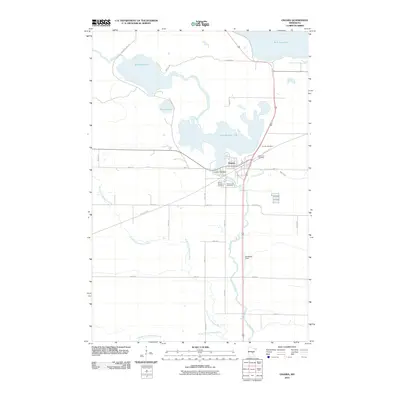
2010 Map of Onamia
USGS Topo · Published 2010About this map
Onamia serves as the central hub of this northern Minnesota landscape, situated at the southern outlet of Lake Onamia. This 2010 survey illustrates a town defined by its relationship with the water and its transportation history, most notably the conversion of the old rail corridor into the Soo Line Trl. The hydrological network is complex, featuring the Rum River winding south from the Onamia Lake Dam and the southern reaches of Mille Lacs Lake visible at the northern edge. Genealogists can identify several local burial sites, including Crosier Cemetery, Holy Cross Cemetery, and Mount Pleasant Cemetery. The surrounding terrain is a network of smaller lakes like Shakopee Lake and Warren Lake, interspersed with drainage ways such as the North Fork Bradbury Brook. This documentation provides a clear view of the area's rural development and the preservation of its timber and rail-era infrastructure for modern recreational use.
Find a feature on this map
29 named features on this map. Tap any name to fly to it.
Don’t see what you’re looking for? This feature index may not catch every label — zoom into the map to look around manually.
Map Details
Editions of this 2010 Onamia Map
This is the sole edition of this map. No revisions or reprints were ever made.
Other maps of this area

1953 · Duluth
USGS Topo · 1:250,000

1953 · Stillwater
USGS Topo · 1:250,000

1955 · Stillwater
USGS Topo · 1:250,000

1958 · Stillwater
USGS Topo · 1:250,000

1958 · Duluth
USGS Topo · 1:250,000

1965 · Stillwater
USGS Topo · 1:250,000

1968 · Onamia NW
USGS Topo · 1:24,000

1968 · Ramey NE
USGS Topo · 1:24,000

1968 · Milaca NE
USGS Topo · 1:24,000

1968 · Onamia
USGS Topo · 1:24,000