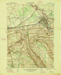
1947 Map of Oneida
USGS Topo · Published 1947About this map
The industrial and transit history of central New York is etched into the landscape of the Madison and Oneida County line, where the New York Central and New York Ontario and Western railroads converge. This post-war survey documents a region defined by the legacy of the Erie Canal (Abandoned), which passes north of Lenox Basin. While the city of Oneida serves as a dense hub featuring the local Armory and City Hall, the surrounding countryside is dotted with smaller hamlets like Wampsville and Oneida Castle.
Find a feature on this map
46 named features on this map. Tap any name to fly to it.
Don’t see what you’re looking for? This feature index may not catch every label — zoom into the map to look around manually.
Map Details
Editions of this 1947 Oneida Map
This is the sole edition of this map. No revisions or reprints were ever made.
Other maps of this area

1895 · Chittenango
USGS Topo · 1:62,500

1895 · Oneida
USGS Topo · 1:62,500

1897 · Cazenovia
USGS Topo · 1:62,500

1898 · Oneida
USGS Topo · 1:62,500

1898 · Chittenango
USGS Topo · 1:62,500

1899 · Cazenovia
USGS Topo · 1:62,500

1902 · Chittenango
USGS Topo · 1:62,500

1902 · Morrisville
USGS Topo · 1:62,500

1902 · Oneida
USGS Topo · 1:62,500

1939 · Oneida
USGS Topo · 1:62,500