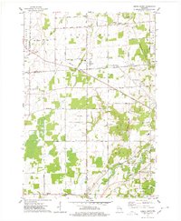
1974 Map of Oneida North
USGS Topo · Published 1978About this map
The Suamico River and its South Branch cut across a landscape defined by dairy farming and evolving municipal boundaries in the mid-1970s. This area, spanning the intersection of Brown, Outagamie, and Shawano counties, shows a series of small rural centers like Kunesh, Pittsfield, and Anston connected by straight-line section roads. The southern portion of the map is dominated by the Oneida community and the State Reformatory Far, reflecting the complex land-use patterns of the region. Local history is anchored by rural institutions, from the Lannoye Sch and Peace Ch to several family-named burial grounds like Owego Cem and Zion Cem. The Chicago and North Western railroad provides a clear industrial corridor through the northeast, while numerous sandpits across the terrain indicate the geological remnants of the region's glacial past.
Find a feature on this map
47 named features on this map. Tap any name to fly to it.
Don’t see what you’re looking for? This feature index may not catch every label — zoom into the map to look around manually.
Map Details
Editions of this 1974 Oneida North Map
This is the sole edition of this map. No revisions or reprints were ever made.
Other maps of this area

1954 · De Pere
USGS Topo · 1:62,500

1954 · Green Bay West
USGS Topo · 1:24,000

1954 · De Pere
USGS Topo · 1:24,000

1954 · Green Bay
USGS Topo · 1:62,500

1955 · Appleton
USGS Topo · 1:62,500

1955 · Seymour
USGS Topo · 1:62,500

1955 · Green Bay
USGS Topo · 1:250,000

1974 · Seymour
USGS Topo · 1:24,000

1974 · Zachow
USGS Topo · 1:24,000
1974 · Oneida South
USGS Topo · 1:24,000