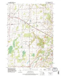
1992 Map of Oneida North
USGS Topo · Published 1996About this map
The Suamico River and its several branches carve through the agricultural and residential transition zone northwest of Green Bay. This 1990s revision reveals a landscape shaped by the intersection of Brown and Outagamie counties, where small communities like Pittsfield and Anston maintain distinct identities amid expanding corporate boundaries. A notable institutional presence is found at the State Reformatory Farm, which occupies a significant portion of the central terrain.
Find a feature on this map
43 named features on this map. Tap any name to fly to it.
Don’t see what you’re looking for? This feature index may not catch every label — zoom into the map to look around manually.
Map Details
Editions of this 1992 Oneida North Map
This is the sole edition of this map. No revisions or reprints were ever made.
Other maps of this area

1954 · De Pere
USGS Topo · 1:62,500

1954 · Green Bay West
USGS Topo · 1:24,000

1954 · De Pere
USGS Topo · 1:24,000

1954 · Green Bay
USGS Topo · 1:62,500

1955 · Appleton
USGS Topo · 1:62,500

1955 · Seymour
USGS Topo · 1:62,500

1955 · Green Bay
USGS Topo · 1:250,000

1974 · Seymour
USGS Topo · 1:24,000

1974 · Zachow
USGS Topo · 1:24,000
1974 · Oneida South
USGS Topo · 1:24,000