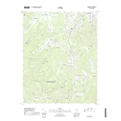
2019 Map of Oneida South
USGS Topo · Published 2019About this map
Helenwood and Oneida anchor the eastern ridge of this plateau landscape, where the settlements follow the corridor of the Bsfm Rara railroad. This 2019 survey documents a region defined by a dense network of family and community burial grounds, including Pemberton Cem, New Haven Cem, and Marcum Cem, which are often located near small rural centers like Verdun and Black Oak. To the west, the terrain drops away into the protected wilderness of the Big South Fork National River and Recreation Area. Along the New River, the topography is marked by distinctive local landmarks such as Negro Bend, McCoy Rocks, and Bendix Spur. The map also illustrates the modern infrastructure of Scott Municipal Airport positioned atop Big Ridge, contrasting with the numerous hollows and gaps like Cecil Hollow and Low Gap that define the local drainage patterns.
Find a feature on this map
192 named features on this map. Tap any name to fly to it.
Don’t see what you’re looking for? This feature index may not catch every label — zoom into the map to look around manually.
Map Details
Editions of this 2019 Oneida South Map
This is the sole edition of this map. No revisions or reprints were ever made.
Other maps of this area

1890 · Williamsburg
USGS Topo · 1:125,000

1893 · Briceville
USGS Topo · 1:125,000

1894 · Williamsburg
USGS Topo · 1:125,000

1895 · Wartburg
USGS Topo · 1:125,000

1895 · Briceville
USGS Topo · 1:125,000

1896 · Wartburg
USGS Topo · 1:125,000

1896 · Briceville
USGS Topo · 1:125,000

1934 · Barthell
USGS Topo · 1:62,500

1952 · Helenwood
USGS Topo · 1:24,000

1952 · Honey Creek
USGS Topo · 1:24,000