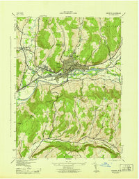
1945 Map of Oneonta
USGS Topo · Published 1945About this map
Oneonta serves as a significant educational and medical hub in this mid-1940s survey, dominated by the campus of the State Teachers College and Hartwick College perched above the river valley. The regional importance of the city is emphasized by the presence of the large Homer Folks State Hospital complex and the Parshall Hospital. Transport and commerce follow the corridor of the Susquehanna River, where the Delaware and Hudson RR and the Southern New York RR converge to navigate the steep terrain between Franklin Mountain and the northern heights.
Find a feature on this map
47 named features on this map. Tap any name to fly to it.
Don’t see what you’re looking for? This feature index may not catch every label — zoom into the map to look around manually.
Map Details
Editions of this 1945 Oneonta Map
This is the sole edition of this map. No revisions or reprints were ever made.
Other maps of this area

1907 · Cooperstown
USGS Topo · 1:62,500

1909 · Cooperstown
USGS Topo · 1:62,500

1909 · Delhi
USGS Topo · 1:62,500

1910 · Hartwick
USGS Topo · 1:62,500

1911 · Delhi
USGS Topo · 1:62,500

1912 · Hartwick
USGS Topo · 1:62,500

1915 · Oneonta
USGS Topo · 1:62,500

1918 · Oneonta
USGS Topo · 1:62,500

1943 · Delhi
USGS Topo · 1:24,000

1943 · Mt Vision
USGS Topo · 1:24,000