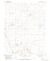
1969 Map of Ong
USGS Topo · Published 1971About this map
Ong stands as a focal point in this south-central Nebraska landscape, situated at the intersection of Logan and Bryant townships. The village is tightly clustered along the Burlington Northern railroad, reflecting the critical role of rail transport in the regional agricultural economy during the late 1960s. The surrounding countryside is defined by a series of significant waterfowl habitats, including the Krause Lagoon National Wildlife Management Area, Hansen Lagoon National Wildlife Management Area, and Mallard Haven National Wildlife Management Area. These managed wetlands and lagoons contrast with the rectilinear grid of section lines and farmsteads. Local genealogy is well-preserved through several rural burial sites and places of worship, such as Ong Cemetery, Fairview Cemetery, and the Swedish Cemetery located near Stockholm Church. The terrain is drained by the meandering paths of Little Sandy Creek and Turkey Creek, which break the geometric patterns of the plains.
Find a feature on this map
16 named features on this map. Tap any name to fly to it.
Don’t see what you’re looking for? This feature index may not catch every label — zoom into the map to look around manually.
Map Details
Editions of this 1969 Ong Map
This is the sole edition of this map. No revisions or reprints were ever made.
Other maps of this area

1898 · York
USGS Topo · 1:125,000

1898 · Hebron
USGS Topo · 1:125,000

1899 · York
USGS Topo · 1:125,000

1955 · Lincoln
USGS Topo · 1:250,000

1957 · Lincoln
USGS Topo · 1:250,000

1958 · Lincoln
USGS Topo · 1:250,000

1960 · Edgar
USGS Topo · 1:24,000

1960 · Davenport
USGS Topo · 1:24,000

1960 · Carleton
USGS Topo · 1:24,000
1969 · Saronville
USGS Topo · 1:24,000