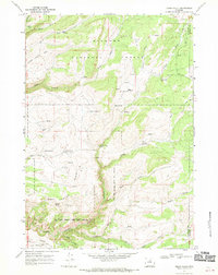
1967 Map of Onion Gulch
USGS Topo · Published 1970About this map
The Girl Scout National Center West boundary occupies the central heart of this high-plateau landscape within the Bighorn National Forest. This 1967 survey documents a high-country economy defined by seasonal grazing and homesteading, evidenced by the scattered presence of the Rice Cow Camp, Lyman Cow Camp, and individual dwellings like the Moses Homestead and Tolman Homestead. The physical geography is marked by the Canyon Creek Sinks and the prominent Vee Ridge, where water sources like Healy Springs and Camino Spring were critical for both wildlife and the livestock of the nearby camps. Remote cabins, including the Hatfield Cabin and Basset Cabin, underscore the isolation of these drainage basins before modern road development reached this corner of Washakie and Johnson County.
Find a feature on this map
36 named features on this map. Tap any name to fly to it.
Don’t see what you’re looking for? This feature index may not catch every label — zoom into the map to look around manually.
Map Details
Editions of this 1967 Onion Gulch Map
2 editions found
Other maps of this area

1899 · Cloud peak
USGS Topo · 1:125,000

1901 · Cloud Peak
USGS Topo · 1:125,000

1955 · Sheridan
USGS Topo · 1:250,000

1955 · Arminto
USGS Topo · 1:250,000

1958 · Sheridan
USGS Topo · 1:250,000

1958 · Arminto
USGS Topo · 1:250,000

1962 · Sheridan
USGS Topo · 1:250,000

1962 · Arminto
USGS Topo · 1:250,000

1966 · Monument Hill
USGS Topo · 1:24,000

1966 · Big Trails NE
USGS Topo · 1:24,000