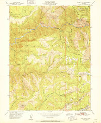
1951 Map of Onion Valley
USGS Topo · Published 1951About this map
Middle Fork Feather River carves a deep canyon through this portion of the northern Sierra Nevada, where the 1951 landscape is defined by a legacy of gold and mineral extraction. The map reveals a transition toward post-mining industry, with numerous sites such as the White Pine Chrome Mine and the Wilson-Gomez Mine listed as inactive. Settlements like McCarthy Bar and Rich Bar cling to the riverbanks, while higher elevations within the Plumas National Forest show the footprint of earlier habitations at Onion Valley (Site) and Last Chance (Site). The terrain is crisscrossed by historic routes like the Gibsonville Trail and Claremont Trail, which once served remote outposts and diggings. Evidence of hydraulic and placer mining remains visible at Mister Diggings, illustrating the intensive labor that shaped the drainages of Onion Valley Creek and the South Fork Feather River before the mid-20th century.
Find a feature on this map
77 named features on this map. Tap any name to fly to it.
Don’t see what you’re looking for? This feature index may not catch every label — zoom into the map to look around manually.
Map Details
Editions of this 1951 Onion Valley Map
This is the sole edition of this map. No revisions or reprints were ever made.
Other maps of this area

1888 · Bidwell Bar
USGS Topo · 1:125,000

1891 · Bidwell Bar
USGS Topo · 1:125,000

1891 · Downieville
USGS Topo · 1:125,000

1893 · Bidwell Bar
USGS Topo · 1:125,000

1893 · Downieville
USGS Topo · 1:125,000

1895 · Bidwell Bar
USGS Topo · 1:125,000

1895 · Downieville
USGS Topo · 1:125,000

1896 · Downieville
USGS Topo · 1:125,000

1897 · Bidwell Bar
USGS Topo · 1:125,000

1897 · Downieville
USGS Topo · 1:125,000