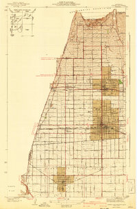
1942 Map of Ontario and Vicinity
USGS Topo · Published 1942About this map
The San Gabriel Mountains loom over a landscape of burgeoning orchards and transit lines during the early 1940s. Centered on the growing citrus hubs of Ontario and Upland, the map reveals a meticulously gridded agricultural and residential corridor transitioning into the Puente Hills. Significant infrastructure defines the era, with the Atchison Topeka and Santa Fe and Southern Pacific railroads cutting through the valley, facilitating the region's famed fruit industry. Local life is anchored by landmarks like College Hill, the Sierra Vista Sch, and the Bellevue Cem. Smaller rail-side settlements such as Narod and Sunsweet underscore the local economy's dependence on the tracks. From the higher elevations of San Antonio Heights down to Chino, the map documents the early suburban and industrial footprint of the Inland Empire before mid-century expansion fundamentally altered the valley floor.
Find a feature on this map
52 named features on this map. Tap any name to fly to it.
Don’t see what you’re looking for? This feature index may not catch every label — zoom into the map to look around manually.
Map Details
Editions of this 1942 Ontario and Vicinity Map
2 editions found
Other maps of this area

1894 · Pomona
USGS Topo · 1:62,500

1896 · Anaheim
USGS Topo · 1:62,500

1897 · Pomona
USGS Topo · 1:62,500

1897 · Cucamonga
USGS Topo · 1:62,500

1898 · Pomona
USGS Topo · 1:62,500

1898 · Anaheim
USGS Topo · 1:62,500

1900 · Cucamonga
USGS Topo · 1:62,500

1901 · Southern California Sheet No. 1
USGS Topo · 1:250,000

1901 · Anaheim
USGS Topo · 1:62,500

1902 · Corona
USGS Topo · 1:125,000