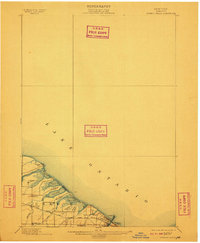
1899 Map of Ontario Beach
USGS Topo · Published 1910About this map
Lake Ontario's southern shoreline in the town of Greece is defined by a series of coastal ponds and early resort-era transit lines in this late 19th-century survey. The landscape features a chain of marshy lagoons including Braddock Bay, Cranberry Pond, and Long Pond, separated from the lake by narrow barrier beaches. Public transportation is a focal point of the local economy, shown through the Grand View Beach Electric R. R. running parallel to the water and the New York Central and Hudson River R. R. serving the inland settlements. Local life centers on clusters like Greece Sta. and North Greece, while the Genesee R. mouth is marked by the Genesee L.H., anchoring the developments at Ontario Beach and Windsor Beach. This map documents a period when the Monroe County lakefront was transitioning from rural wetlands into a premier summer destination.
Find a feature on this map
29 named features on this map. Tap any name to fly to it.
Don’t see what you’re looking for? This feature index may not catch every label — zoom into the map to look around manually.
Map Details
Editions of this 1899 Ontario Beach Map
3 editions found
Other maps of this area

1895 · Rochester
USGS Topo · 1:62,500

1895 · Ontario Beach
USGS Topo · 1:62,500

1898 · Rochester
USGS Topo · 1:62,500

1899 · Hamlin
USGS Topo · 1:62,500

1899 · Ontario Beach
USGS Topo · 1:62,500

1899 · Brockport
USGS Topo · 1:62,500

1900 · Macedon
USGS Topo · 1:62,500

1912 · Rochester
USGS Topo · 1:62,500

1912 · Ontario Beach
USGS Topo · 1:62,500

1920 · Rochester
USGS Topo · 1:62,500