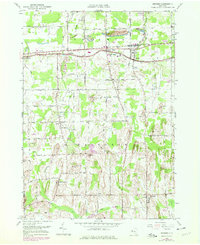
1952 Map of Ontario
USGS Topo · Published 1978About this map
Ontario and the surrounding townships of northwestern Wayne County are depicted here in a landscape shaped by agricultural patterns and rising post-war development. The corridor following Ridge Road serves as the primary artery for local growth, connecting settlements like Ontario Center and Fruitland. To the south, the terrain becomes more distinct with drumlin formations like Jacobs Hill and Mathewson Hill rising above the drainage of Mill Creek and Bear Creek. The community of Walworth anchors the southern portion of the sheet, while institutional landmarks such as Wayne Central Sch and several local burial grounds, including Furnaceville Cem and Baker Cem, provide valuable reference points for genealogical research. The presence of the Penn Central rail line cutting through the north reflects the area's historical connection to regional trade routes between Rochester and the finger lakes region.
Find a feature on this map
57 named features on this map. Tap any name to fly to it.
Don’t see what you’re looking for? This feature index may not catch every label — zoom into the map to look around manually.
Map Details
Editions of this 1952 Ontario Map
Other maps of this area

1899 · Palmyra
USGS Topo · 1:62,500

1900 · Macedon
USGS Topo · 1:62,500

1902 · Pultneyville
USGS Topo · 1:62,500

1902 · Palmyra
USGS Topo · 1:62,500

1932 · Webster
USGS Topo · 1:24,000

1932 · Fairport
USGS Topo · 1:24,000

1934 · Fairport
USGS Topo · 1:24,000
1934 · Ninemile Point
USGS Topo · 1:24,000

1934 · Webster
USGS Topo · 1:24,000

1942 · Ontario
USGS Topo · 1:31,680