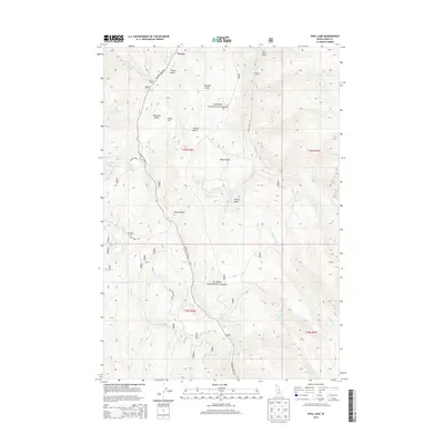
2013 Map of Opal Lake
USGS Topo · Published 2013About this map
Salmon National Forest defines the rugged geography of this Lemhi County landscape, where deep gulches and basins dictate the path of travel. The settlement at Forney sits near the northern boundary, serving as a focal point for the surrounding canyon network. Long-standing land use is evident through the presence of established homesteads such as Merritt Ranch and Kingsbury Ranch, positioned along the drainage of Panther Cr. The terrain is characterized by a series of high-elevation depressions, including Moyer Basin, Prairie Basin, and Rooker Basin, which are connected by forest service routes like Nat For Dev Rd 383. Moving toward the southeast, the landscape rises toward the namesake Opal Lake, the headwaters for several mountain streams including Opal Cr and Weasel Cr. This modern survey provides a clear view of the drainage patterns and historical ranching sites within the interior of Idaho's wilderness.
Find a feature on this map
32 named features on this map. Tap any name to fly to it.
Don’t see what you’re looking for? This feature index may not catch every label — zoom into the map to look around manually.
Map Details
Editions of this 2013 Opal Lake Map
This is the sole edition of this map. No revisions or reprints were ever made.
Other maps of this area
1950 · Blackbird Mtn
USGS Topo · 1:62,500
1950 · Leesburg
USGS Topo · 1:62,500
1951 · Leesburg
USGS Topo · 1:62,500
1951 · Blackbird Mtn
USGS Topo · 1:62,500

1956 · Elk City
USGS Topo · 1:250,000

1957 · Challis
USGS Topo · 1:250,000

1960 · Elk City
USGS Topo · 1:250,000

1960 · Challis
USGS Topo · 1:250,000

1963 · Challis
USGS Topo · 1:250,000
1963 · Opal Lake
USGS Topo · 1:24,000