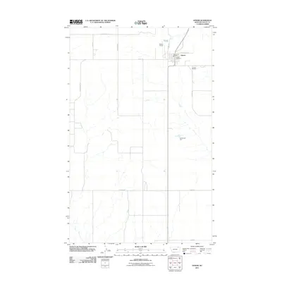
2011 Map of Opheim
USGS Topo · Published 2011About this map
The small plains town of Opheim anchors this high-desert landscape in northern Montana, serving as a vital hub for the surrounding agricultural community. The map details the essential infrastructure of a rural outpost, including the Opheim Post Office, the Opheim Vol Fire Dept, and the nearby Opheim Airport. The grid-like organization of the landscape is defined by long, straight gravel routes such as Coal Mine Hill Rd and Golden Valley Rd, which reflect the vast township and range surveying system. East of the town center, Lawndale Cemetery provides a historical point of reference for genealogists, while the A Anderson Dam to the southeast marks a rare water management feature in this arid region. The arrangement of family-named roads like Edwards Rd and Dewitt Rd suggests a landscape shaped by persistent homesteading and ranching legacy in Valley County.
Find a feature on this map
17 named features on this map. Tap any name to fly to it.
Don’t see what you’re looking for? This feature index may not catch every label — zoom into the map to look around manually.
Map Details
Editions of this 2011 Opheim Map
This is the sole edition of this map. No revisions or reprints were ever made.
Other maps of this area

1919 · Boundary
USGS Topo · 1:125,000

1954 · Glasgow
USGS Topo · 1:250,000

1957 · Glasgow
USGS Topo · 1:250,000

1958 · Glasgow
USGS Topo · 1:250,000

1973 · Glentana West
USGS Topo · 1:24,000

1973 · Baylor NE
USGS Topo · 1:24,000

1973 · Baylor
USGS Topo · 1:24,000

1973 · Opheim
USGS Topo · 1:24,000

1973 · Roanwood
USGS Topo · 1:24,000
1973 · Glass Hill
USGS Topo · 1:24,000