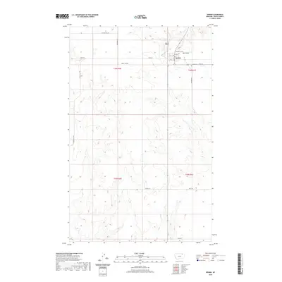
2020 Map of Opheim
USGS Topo · Published 2020About this map
Opheim, a small northern Montana community, serves as the primary hub of activity on this prairie landscape in Valley County. The town site is defined by a grid of local streets including Main St, 1st Ave S, and 2nd Ave N, with the Opheim Airport situated immediately to the north. The surrounding terrain is characterized by the rolling draws of Snow Coulee and Bog Coulee, which drain the expansive agricultural lands. Local history and genealogy interest is concentrated at the Lawndale Cem, located southeast of the town center. The map reveals a network of rural roads such as Coal Mine Hill Rd and Theony Rd that link the various sections of T36N and T35N, reflecting the township and range system that organizes this portion of the Great Plains.
Find a feature on this map
23 named features on this map. Tap any name to fly to it.
Don’t see what you’re looking for? This feature index may not catch every label — zoom into the map to look around manually.
Map Details
Editions of this 2020 Opheim Map
This is the sole edition of this map. No revisions or reprints were ever made.
Other maps of this area

1919 · Boundary
USGS Topo · 1:125,000

1954 · Glasgow
USGS Topo · 1:250,000

1957 · Glasgow
USGS Topo · 1:250,000

1958 · Glasgow
USGS Topo · 1:250,000

1973 · Glentana West
USGS Topo · 1:24,000

1973 · Baylor NE
USGS Topo · 1:24,000

1973 · Baylor
USGS Topo · 1:24,000

1973 · Opheim
USGS Topo · 1:24,000

1973 · Roanwood
USGS Topo · 1:24,000
1973 · Glass Hill
USGS Topo · 1:24,000