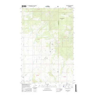
2017 Map of Ophir Creek
USGS Topo · Published 2017About this map
The Avon Valley and the small settlement of Avon serve as the southern anchor for this map, where the terrain transitions from the valley floor into the high, wooded slopes of the Helena National Forest. A complex drainage system defines the landscape, with Ophir Creek and its many tributaries, such as North Fork Ophir Creek and Carpenter Creek, carving through steep ridges. The presence of the Blackfoot Cemetery near Illinois Gulch and the naming of Blackfoot City Road point toward the area's historical mining and settlement patterns, even as the higher elevations remain dominated by natural landmarks like Black Mountain and Illinois Ridge. Local travel is dictated by the rugged topography, followed by routes like Three Mile Road and Ophir Creek Road that wind through the gulches.
Find a feature on this map
35 named features on this map. Tap any name to fly to it.
Don’t see what you’re looking for? This feature index may not catch every label — zoom into the map to look around manually.
Map Details
Editions of this 2017 Ophir Creek Map
This is the sole edition of this map. No revisions or reprints were ever made.
Other maps of this area
1889 · Helena
USGS Topo · 1:250,000
1893 · Helena
USGS Topo · 1:250,000
1899 · Helena
USGS Topo · 1:250,000
1903 · Helena
USGS Topo · 1:250,000

1947 · Butte
USGS Topo · 1:250,000

1958 · Butte
USGS Topo · 1:250,000
1958 · Avon
USGS Topo · 1:62,500
1959 · Elliston
USGS Topo · 1:62,500
1960 · Butte
USGS Topo · 1:250,000
1962 · Butte
USGS Topo · 1:250,000