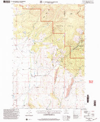
2001 Map of Ophir Creek
USGS Topo · Published 2004About this map
The high country of Helena National Forest along the Continental Divide defines this rugged section of Montana. Extensive mining activity is evident throughout the terrain, particularly near Blackfoot City, where numerous Quarries, Mine Shafts, and the Victory Mine are documented. The landscape is a network of steep drainages, including Ophir Creek and Carpenter Creek, where Placer Mines operated along the narrow valley floors.
Find a feature on this map
42 named features on this map. Tap any name to fly to it.
Don’t see what you’re looking for? This feature index may not catch every label — zoom into the map to look around manually.
Map Details
Editions of this 2001 Ophir Creek Map
This is the sole edition of this map. No revisions or reprints were ever made.
Other maps of this area

1889 · Helena
USGS Topo · 1:250,000

1893 · Helena
USGS Topo · 1:250,000

1899 · Helena
USGS Topo · 1:250,000

1903 · Helena
USGS Topo · 1:250,000

1947 · Butte
USGS Topo · 1:250,000

1958 · Butte
USGS Topo · 1:250,000

1958 · Avon
USGS Topo · 1:62,500

1959 · Elliston
USGS Topo · 1:62,500

1960 · Butte
USGS Topo · 1:250,000

1962 · Butte
USGS Topo · 1:250,000