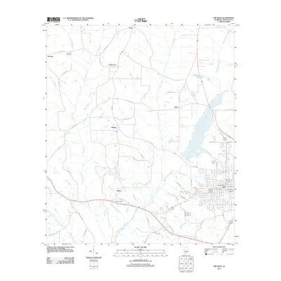
2011 Map of Opp West
USGS Topo · Published 2011About this map
Opp and its western rural neighbors anchor this 2011 survey, showing a landscape defined by the winding Yellow River and the expansive Lightwood Knot Creek drainage. The map details the transition from the city's residential streets, such as Douglas Ave and Rush St, into the surrounding agricultural communities of Babbie, Wiggins, and Opine. This era of Covington County development is marked by a blend of traditional landmarks and newer infrastructure, ranging from the Opp Post Office to the Old Dragstrip near Harmony.
Find a feature on this map
62 named features on this map. Tap any name to fly to it.
Don’t see what you’re looking for? This feature index may not catch every label — zoom into the map to look around manually.
Map Details
Editions of this 2011 Opp West Map
This is the sole edition of this map. No revisions or reprints were ever made.
Other maps of this area

1953 · Andalusia
USGS Topo · 1:250,000

1957 · Andalusia
USGS Topo · 1:250,000

1968 · Danleys Crossroads
USGS Topo · 1:24,000

1968 · Opp East
USGS Topo · 1:24,000
1969 · Kinston
USGS Topo · 1:24,000

1971 · Libertyville
USGS Topo · 1:24,000

1971 · Dozier
USGS Topo · 1:24,000

1971 · Onycha
USGS Topo · 1:24,000

1971 · Andalusia
USGS Topo · 1:24,000

1971 · Gantt
USGS Topo · 1:24,000