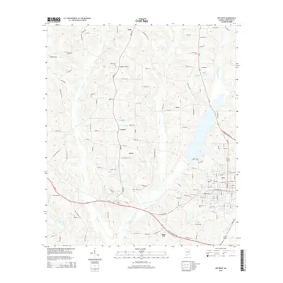
2014 Map of Opp West
USGS Topo · Published 2014About this map
The Yellow River flows through the western portions of this Covington County landscape, defining a terrain marked by numerous creek branches and small rural settlements. In the east, the city of Opp serves as the primary municipal center, where grid-patterned streets meet larger thoroughfares like Us-84. The surrounding countryside is dotted with established communities such as Babbie, Cedar Grove, and Harmony, each connected by a network of county roads including Babbie Rd and Nelson Rd.
Find a feature on this map
132 named features on this map. Tap any name to fly to it.
Don’t see what you’re looking for? This feature index may not catch every label — zoom into the map to look around manually.
Map Details
Editions of this 2014 Opp West Map
This is the sole edition of this map. No revisions or reprints were ever made.
Other maps of this area

1953 · Andalusia
USGS Topo · 1:250,000

1957 · Andalusia
USGS Topo · 1:250,000

1968 · Danleys Crossroads
USGS Topo · 1:24,000

1968 · Opp East
USGS Topo · 1:24,000
1969 · Kinston
USGS Topo · 1:24,000

1971 · Libertyville
USGS Topo · 1:24,000

1971 · Dozier
USGS Topo · 1:24,000

1971 · Onycha
USGS Topo · 1:24,000

1971 · Andalusia
USGS Topo · 1:24,000

1971 · Gantt
USGS Topo · 1:24,000