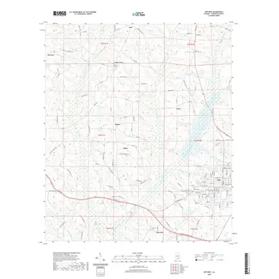
2020 Map of Opp West
USGS Topo · Published 2020About this map
The western outskirts of Opp and the rural communities of Covington County are captured here in a landscape defined by the upper reaches of the Yellow River. In this contemporary survey, the intricate drainage network of Lightwood Knot Creek and Cameron Creek carves through the undulating terrain, punctuated by family-named landmarks and long-established crossroads. The map documents numerous small settlements such as Harmony, Babbie, and Wiggins, alongside several community burial grounds including Bethel Cem, Henderson Cem, and Sweet Home Cem 32. These features, along with names like Oscar Pugh Rd and Sasser Br, offer valuable data for those tracing local family history in the Alabama wiregrass region. The transition from the urban grid of Opp to the scattered homesteads at Horn Hill and Opine illustrates the enduring rural character and the network of county roads that have connected these hamlets for generations.
Find a feature on this map
128 named features on this map. Tap any name to fly to it.
Don’t see what you’re looking for? This feature index may not catch every label — zoom into the map to look around manually.
Map Details
Editions of this 2020 Opp West Map
This is the sole edition of this map. No revisions or reprints were ever made.
Other maps of this area

1953 · Andalusia
USGS Topo · 1:250,000

1957 · Andalusia
USGS Topo · 1:250,000

1968 · Danleys Crossroads
USGS Topo · 1:24,000

1968 · Opp East
USGS Topo · 1:24,000
1969 · Kinston
USGS Topo · 1:24,000

1971 · Libertyville
USGS Topo · 1:24,000

1971 · Dozier
USGS Topo · 1:24,000

1971 · Onycha
USGS Topo · 1:24,000

1971 · Andalusia
USGS Topo · 1:24,000

1971 · Gantt
USGS Topo · 1:24,000