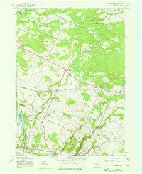
1945 Map of Oppenheim
USGS Topo · Published 1976About this map
St Johnsville anchors the southern edge of this mid-century landscape, where the Mohawk R and the New York Central railroad corridor drive the local economy. The terrain transitions from the river valley into the southern reaches of Adirondack Park, marked by a network of rural hamlets like Oppenheim, Crum Creek, and Lotville. This 1940s field-checked survey reveals a high density of small-scale educational and commemorative sites, including Yonker Bush Sch and numerous family-named burial grounds such as Clemmons Cem and Klock Cem. The map illustrates a well-developed network of creeks, including Middle Sprite Creek and Timmerman Creek, which historically dictated the placement of settlements and roads before the era of modern highway expansion. Significant local landmarks like Twin Church Hill and Klock-Park provide distinct points of reference for genealogists tracing family land holdings near the Montgomery and Fulton county lines.
Find a feature on this map
49 named features on this map. Tap any name to fly to it.
Don’t see what you’re looking for? This feature index may not catch every label — zoom into the map to look around manually.
Map Details
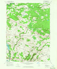
Editions of this 1945 Oppenheim Map
2 editions found
Other maps of this area

1898 · Canajoharie
USGS Topo · 1:62,500

1900 · Little Falls
USGS Topo · 1:62,500

1900 · Canajoharie
USGS Topo · 1:62,500

1901 · Lassellsville
USGS Topo · 1:62,500

1902 · Canajoharie
USGS Topo · 1:62,500

1903 · Richfield Springs
USGS Topo · 1:62,500

1903 · Lassellsville
USGS Topo · 1:62,500

1903 · Little Falls
USGS Topo · 1:62,500

1939 · Little Falls
USGS Topo · 1:62,500
1943 · Little Falls
USGS Topo · 1:24,000