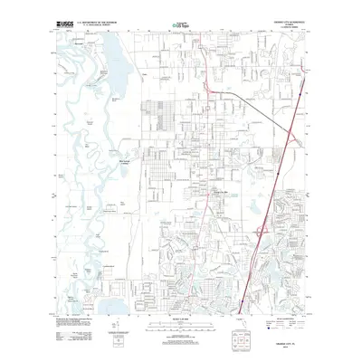
2012 Map of Orange City
USGS Topo · Published 2012About this map
The Saint Johns River defines the western edge of this landscape, winding through a complex of islands and cutoffs including Hontoon Island, Scrub Island, and Goat Island. On the mainland, the residential development of Orange City Hills and the historic settlement of Fatio sit atop a terrace dotted with numerous sinkhole lakes. This transition from the river’s swampy bottomlands, featuring the Snake Creek Cutoff and Blue Springs Run, to the elevated inland areas highlights the region's diverse hydrology. Local history is anchored by several long-standing burial grounds such as Lincoln Cem, Hollywood Cem, and the Missionary Baptist Church Cem. Landmarks like the Orange City Lookout Tower and the Coral Oaks Golf Course serve as modern community focal points, while the dense network of landings along the river, including Starks Landing and Emanuel Landing, points to the area's heritage as a riverfront corridor.
Find a feature on this map
209 named features on this map. Tap any name to fly to it.
Don’t see what you’re looking for? This feature index may not catch every label — zoom into the map to look around manually.
Map Details
Editions of this 2012 Orange City Map
This is the sole edition of this map. No revisions or reprints were ever made.
Other maps of this area

1954 · Daytona Beach
USGS Topo · 1:250,000

1955 · Orlando
USGS Topo · 1:250,000

1957 · Orlando
USGS Topo · 1:250,000

1958 · Orlando
USGS Topo · 1:250,000

1958 · Daytona Beach
USGS Topo · 1:250,000

1962 · Orlando
USGS Topo · 1:250,000

1962 · Pine Lakes
USGS Topo · 1:24,000

1962 · Daytona Beach SW
USGS Topo · 1:24,000

1962 · Lake Woodruff
USGS Topo · 1:24,000

1964 · Daytona Beach
USGS Topo · 1:250,000