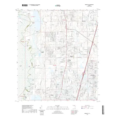
2018 Map of Orange City
USGS Topo · Published 2018About this map
The Saint Johns River defines the western edge of this Volusia County landscape, where the water fragments into a complex network of channels and islands including Hontoon Island and Live Oak Island. The river's winding path creates distinctive features like Dutchmans Bend and Florida Bend, which transition into the dense urban grids of Orange City, Deltona, and DeBary to the east. This 2018 survey captures a region defined by its hydrography, showing dozens of small lakes such as Lake Marie and Goose Lake scattered among residential developments. Local history is anchored by several burial grounds, including the Missionary Baptist Church Cem and Enterprise Cem, while the CSX Transportation rail line provides a structural backbone for the inland settlements. The geography here is a study in Florida's modern suburban expansion meeting its original riverine wilderness at Blue Springs Landing.
Find a feature on this map
123 named features on this map. Tap any name to fly to it.
Don’t see what you’re looking for? This feature index may not catch every label — zoom into the map to look around manually.
Map Details
Editions of this 2018 Orange City Map
This is the sole edition of this map. No revisions or reprints were ever made.
Other maps of this area

1954 · Daytona Beach
USGS Topo · 1:250,000

1955 · Orlando
USGS Topo · 1:250,000

1957 · Orlando
USGS Topo · 1:250,000

1958 · Orlando
USGS Topo · 1:250,000

1958 · Daytona Beach
USGS Topo · 1:250,000

1962 · Orlando
USGS Topo · 1:250,000

1962 · Pine Lakes
USGS Topo · 1:24,000

1962 · Daytona Beach SW
USGS Topo · 1:24,000

1962 · Lake Woodruff
USGS Topo · 1:24,000

1964 · Daytona Beach
USGS Topo · 1:250,000