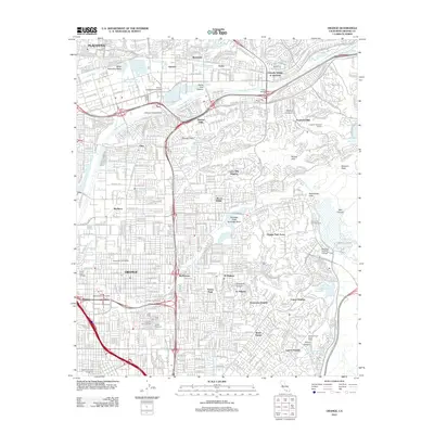
2012 Map of Orange
USGS Topo · Published 2012About this map
Orange and Villa Park anchor this detailed study of the Santa Ana River basin and its surrounding foothills. The landscape is defined by extensive water management infrastructure, including the Santiago Creek Recharge Basin, Anaheim Lake, and the Miller Retarding Basin. These features, along with the Atwood Channel and Carbon Canyon Diversion Channel, reflect the sophisticated engineering required to manage the region's seasonal runoff while supporting residential expansion. The map captures the suburban density of Placentia, Atwood, and El Modena as they press against the terrain of the Peralta Hills and Santiago Canyon. Local heritage is preserved in several prominent burial grounds, such as the Cem of the Holy Sepulchre and the historic Yorba Cem. Educational institutions including Chapman University and Santiago Canyon College appear as major landmarks within the urban fabric, while the Santa Ana River itself remains a central corridor, spanned by the Jefferson Street Bridge and Yorba Bridge.
Find a feature on this map
71 named features on this map. Tap any name to fly to it.
Don’t see what you’re looking for? This feature index may not catch every label — zoom into the map to look around manually.
Map Details
Editions of this 2012 Orange Map
This is the sole edition of this map. No revisions or reprints were ever made.
Other maps of this area

1896 · Santa Ana
USGS Topo · 1:62,500

1896 · Anaheim
USGS Topo · 1:62,500

1898 · Anaheim
USGS Topo · 1:62,500

1901 · Southern California Sheet No. 1
USGS Topo · 1:250,000

1901 · Santa Ana
USGS Topo · 1:62,500

1901 · Anaheim
USGS Topo · 1:62,500

1902 · Corona
USGS Topo · 1:125,000

1904 · Southern California Sheet No. 1
USGS Topo · 1:250,000

1932 · Orange
USGS Topo · 1:31,680

1932 · Newport Beach
USGS Topo · 1:31,680