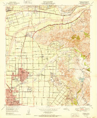
1950 Map of Orange
USGS Topo · Published 1950About this map
The Santa Ana River carves through this Southern California landscape, defining the transition from the floodplains of Orange and Santa Ana to the rising elevations of Santa Ana Canyon. This 1950 survey highlights a region during its post-war citrus era, before the suburban expansion fully transformed the landscape. Notable clusters of local history appear at Villa Park and El Modena, while the presence of Oil Wells near Atwood points to the industrial drivers of the period. Genealogists can find several significant burial grounds, including The Holy Sepulchre and Fairhaven Cem. The infrastructure of the day is marked by the Atchison Topeka and Santa Fe railroad and the Southern Pacific lines, which supported the local agricultural economy. Features like the Yorba Ch (Aban'd) and the Jefferson St Bridge provide tangible links to the earlier ranching and pioneer heritage of the canyon area.
Find a feature on this map
59 named features on this map. Tap any name to fly to it.
Don’t see what you’re looking for? This feature index may not catch every label — zoom into the map to look around manually.
Map Details
Editions of this 1950 Orange Map
This is the sole edition of this map. No revisions or reprints were ever made.
Other maps of this area

1896 · Santa Ana
USGS Topo · 1:62,500

1896 · Anaheim
USGS Topo · 1:62,500

1898 · Anaheim
USGS Topo · 1:62,500

1901 · Southern California Sheet No. 1
USGS Topo · 1:250,000

1901 · Santa Ana
USGS Topo · 1:62,500

1901 · Anaheim
USGS Topo · 1:62,500

1902 · Corona
USGS Topo · 1:125,000

1904 · Southern California Sheet No. 1
USGS Topo · 1:250,000

1932 · Orange
USGS Topo · 1:31,680

1932 · Newport Beach
USGS Topo · 1:31,680