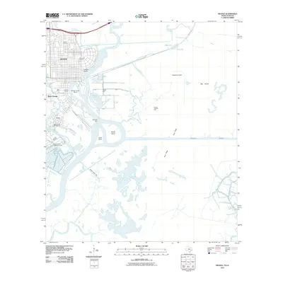
2010 Map of Orange
USGS Topo · Published 2010About this map
Orange and its industrial waterfront define this coastal Texas landscape where the Sabine River snakes through a complex network of bayous and man-made channels. The intersection of heavy industry and local history is visible in the proximity of established burial grounds like Hollywood Cemetery and Evergreen Cemetery to large-scale infrastructure such as the Dupont Plant Reservoir Levee. The area south of West Orange and the neighborhood of Cove shows a transition from urban grids to the marshy lowlands of Pavell Island and Perry Ridge, dominated by energy extraction at the Phoenix Lake Oil Field and the Phoenix Lake Gas Field. Navigation is central to the geography here, anchored by the Intracoastal Waterway and recreational hubs like the Sabine Yacht Basin Marina. This survey records a modern industrial port city deeply integrated with its surrounding waterways, from the narrow Little Cypress Bayou to the broad Black Bayou.
Find a feature on this map
38 named features on this map. Tap any name to fly to it.
Don’t see what you’re looking for? This feature index may not catch every label — zoom into the map to look around manually.
Map Details
Editions of this 2010 Orange Map
This is the sole edition of this map. No revisions or reprints were ever made.
Other maps of this area

1926 · Mauriceville
USGS Topo · 1:24,000

1932 · Orange
USGS Topo · 1:62,500

1932 · Port Arthur NE
USGS Topo · 1:31,680

1934 · Greens Bayou
USGS Topo · 1:24,000

1934 · Five Lakes
USGS Topo · 1:24,000

1935 · Five Lakes
USGS Topo · 1:31,680

1935 · Greens Bayou
USGS Topo · 1:31,680

1943 · West of Greens Bayou
USGS Topo · 1:24,000

1943 · Orangefield
USGS Topo · 1:24,000

1943 · Mauriceville
USGS Topo · 1:24,000