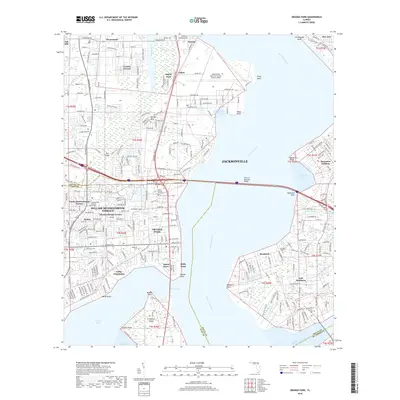
2018 Map of Orange Park
USGS Topo · Published 2018About this map
The Saint Johns River dominates this landscape, serving as a geographic anchor for the suburban developments and military installations south of Jacksonville. Along the western shore, the Jacksonville Naval Air Station (Towers Field) occupies a significant footprint near Yukon, while the Ortega River winds through established neighborhoods like Venetia and Ortega Hills. The map captures the distinct character of Orange Park and the Bellair-Meadowbrook Terrace area, where residential grids are interspersed with local landmarks such as Jacksonville Memory Garden and the scouting grounds of Camp Echockotee. On the eastern bank, the historic community of Mandarin maintains its identity alongside East Mandarin. Family researchers will find value in the clearly marked Magnolia Cem, Mandarin Cem, and Lofton Cem, which document the long-standing settlement of these riverfront communities. The infrastructure is defined by the CSX Transportation line and the crossing of the Henry H Buckman Bridge.
Find a feature on this map
148 named features on this map. Tap any name to fly to it.
Don’t see what you’re looking for? This feature index may not catch every label — zoom into the map to look around manually.
Map Details
Editions of this 2018 Orange Park Map
This is the sole edition of this map. No revisions or reprints were ever made.
Other maps of this area

1917 · Orange Park
USGS Topo · 1:62,500

1917 · Cambon
USGS Topo · 1:62,500

1918 · Middleburg
USGS Topo · 1:62,500

1918 · Cambon
USGS Topo · 1:62,500

1918 · Jacksonville
USGS Topo · 1:62,500

1918 · Orange Park
USGS Topo · 1:62,500

1941 · Middleburg
USGS Topo · 1:62,500

1948 · Jacksonville
USGS Topo · 1:250,000

1949 · Middleburg
USGS Topo · 1:24,000

1949 · Jacksonville Heights
USGS Topo · 1:24,000