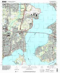
1994 Map of Orange Park
USGS Topo · Published 2002About this map
Jacksonville Naval Air Station dominates the northern riverfront of this mid-1990s survey, showing a complex layout of runways, hangers, and specialized facilities like the NAS Chapel and NAS Hospital. The geography is defined by the massive confluence of the St Johns River and Doctors Inlet, with the Buckman Bridge providing a critical arterial link between the residential communities of Orange Park and Mandarin.
Find a feature on this map
92 named features on this map. Tap any name to fly to it.
Don’t see what you’re looking for? This feature index may not catch every label — zoom into the map to look around manually.
Map Details
Editions of this 1994 Orange Park Map
This is the sole edition of this map. No revisions or reprints were ever made.
Other maps of this area

1917 · Orange Park
USGS Topo · 1:62,500

1917 · Cambon
USGS Topo · 1:62,500

1918 · Middleburg
USGS Topo · 1:62,500

1918 · Cambon
USGS Topo · 1:62,500

1918 · Jacksonville
USGS Topo · 1:62,500

1918 · Orange Park
USGS Topo · 1:62,500

1941 · Middleburg
USGS Topo · 1:62,500

1948 · Jacksonville
USGS Topo · 1:250,000

1949 · Middleburg
USGS Topo · 1:24,000

1949 · Jacksonville Heights
USGS Topo · 1:24,000