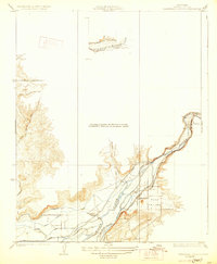
1923 Map of Orangedale School
USGS Topo · Published 1928About this map
Kings River dictates the landscape of this 1920s-era Central Valley survey, where sophisticated irrigation systems define the limits of settlement. The lower reaches of the river are segmented by a dense network of man-made waterways, including the Enterprise Canal, Consolidated Canal, and Fresno Canal, illustrating the intense engineering efforts required to transform the arid valley floor into productive land. Near the base of the foothills, Orangedale School and the settlement of Gravesboro serve as local hubs for farming families.
Find a feature on this map
23 named features on this map. Tap any name to fly to it.
Don’t see what you’re looking for? This feature index may not catch every label — zoom into the map to look around manually.
Map Details
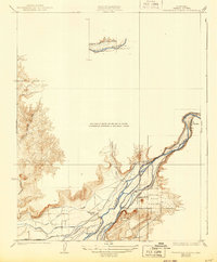
Editions of this 1923 Orangedale School Map
3 editions found
Other maps of this area

1920 · Orangedale School
USGS Topo · 1:24,000

1921 · Squaw Valley
USGS Topo · 1:31,680

1922 · Round Mountain
USGS Topo · 1:31,680

1922 · Trimmer
USGS Topo · 1:96,000

1923 · Academy
USGS Topo · 1:31,680

1923 · Orangedale School
USGS Topo · 1:31,680

1923 · Wahtoke
USGS Topo · 1:31,680

1923 · Sanger
USGS Topo · 1:31,680

1924 · Citrus Cove
USGS Topo · 1:31,680

1924 · Dinuba
USGS Topo · 1:125,000