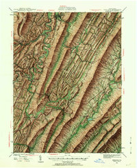
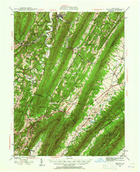
1939 Map of Orbisonia
USGS Topo · Published 1962About this map
Orbisonia and Rockhill anchor the northern landscape of this 1939 survey, situated at the base of Shade Mountain. The region’s transport evolution is evident in the path of the Pennsylvania Turnpike as it cuts through the southern ridges, featuring the Tuscarora Tunnel through the massive Tuscarora Mountain. The map records a dense network of early rural infrastructure, from local mills like Hoovers Mill and Kuhns Mill to numerous mountain gaps such as Keefer Gap and Skinner Gap.
Find a feature on this map
112 named features on this map. Tap any name to fly to it.
Don’t see what you’re looking for? This feature index may not catch every label — zoom into the map to look around manually.
Map Details
Editions of this 1939 Orbisonia Map
7 editions found

Other maps of this area

1900 · Mercersburg
USGS Topo · 1:62,500

1901 · Huntingdon
USGS Topo · 1:62,500

1902 · Chambersburg
USGS Topo · 1:62,500

1902 · Mercersburg
USGS Topo · 1:62,500

1904 · Huntingdon
USGS Topo · 1:62,500

1919 · Mattawana
USGS Topo · 1:62,500

1922 · Mt Union
USGS Topo · 1:48,000

1923 · Shippensburg
USGS Topo · 1:62,500

1924 · Mt. Union
USGS Topo · 1:62,500

1925 · Needmore
USGS Topo · 1:48,000