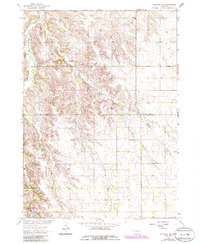
1963 Map of Orchard NE
USGS Topo · Published 1986About this map
Verdigre Creek and Merriman Creek wind through the dissected upland terrain of the Nebraska prairie during the mid-1960s. This survey, later updated with mid-1980s photographic revisions, captures a landscape defined by traditional rural interment sites and protected natural spaces. The Grove Lake State Wildlife Area centers on Grove Lake in the southwestern portion of the sheet, providing a preserved habitat amidst the surrounding agricultural and grazing lands. Genealogists and local historians can locate established burial grounds such as Alcott Cem and Millerboro Cem, which serve as markers of the area's pioneer settlement history. The terrain transitions from the well-defined creek valleys to the flatter sections of the southern reaches, where the Knox Co Antelope Co line divides the landscape.
Find a feature on this map
10 named features on this map. Tap any name to fly to it.
Don’t see what you’re looking for? This feature index may not catch every label — zoom into the map to look around manually.
Map Details
Editions of this 1963 Orchard NE Map
2 editions found
Other maps of this area

1954 · Walnut
USGS Topo · 1:24,000

1954 · Verdigre
USGS Topo · 1:24,000

1955 · Sioux City
USGS Topo · 1:250,000

1955 · O'Neill
USGS Topo · 1:250,000

1958 · Sioux City
USGS Topo · 1:250,000

1959 · O'Neill
USGS Topo · 1:250,000

1959 · Sioux City
USGS Topo · 1:250,000

1963 · Orchard NE
USGS Topo · 1:24,000

1963 · Brunswick
USGS Topo · 1:24,000

1963 · Royal
USGS Topo · 1:24,000