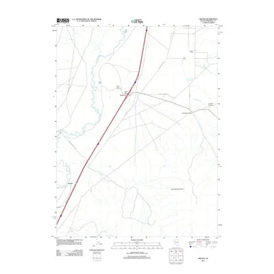
2011 Map of Oreana
USGS Topo · Published 2011About this map
The Humboldt River snakes through the western portion of this Pershing County landscape, providing a critical water source for the scattered operations of this desert region. In the early 21st century, the settlement of Oreana serves as a central point along the Interstate corridor, supported by its own Oreana Post Office and nearby commercial ventures like the Crystal Lakes Trout Farm. To the north, the Etna Post Office sits along the river's path, marking another node of local historical significance.
Find a feature on this map
21 named features on this map. Tap any name to fly to it.
Don’t see what you’re looking for? This feature index may not catch every label — zoom into the map to look around manually.
Map Details
Editions of this 2011 Oreana Map
This is the sole edition of this map. No revisions or reprints were ever made.
Other maps of this area

1931 · Lovelock
USGS Topo · 1:250,000

1935 · Lovelock
USGS Topo · 1:250,000
1954 · Unionville
USGS Topo · 1:62,500
1954 · Buffalo Mtn
USGS Topo · 1:62,500

1955 · Lovelock
USGS Topo · 1:250,000
1956 · Oreana
USGS Topo · 1:62,500
1956 · Lovelock
USGS Topo · 1:62,500

1959 · Lovelock
USGS Topo · 1:250,000
1984 · Lovelock
USGS Topo · 1:100,000
1987 · Rye Patch Dam
USGS Topo · 1:24,000