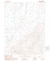
1987 Map of Oreana
USGS Topo · Published 1988About this map
Oreana sits at the base of the West Humboldt Range, serving as a focal point for the mining and transport activity in this part of Nevada during the 1980s. The landscape is defined by the contrast between the flat valley floor where the Humboldt River flows and the steep, mineral-rich slopes to the east. Evidence of the region's industrial past and then-current operations is visible through an extensive network of prospects and established sites, including the Johnson-Heizer Mine, Rosal Mine, and Adriene Mine.
Find a feature on this map
22 named features on this map. Tap any name to fly to it.
Don’t see what you’re looking for? This feature index may not catch every label — zoom into the map to look around manually.
Map Details
Editions of this 1987 Oreana Map
This is the sole edition of this map. No revisions or reprints were ever made.
Other maps of this area

1931 · Lovelock
USGS Topo · 1:250,000

1935 · Lovelock
USGS Topo · 1:250,000

1954 · Unionville
USGS Topo · 1:62,500

1954 · Buffalo Mtn
USGS Topo · 1:62,500

1955 · Lovelock
USGS Topo · 1:250,000

1956 · Oreana
USGS Topo · 1:62,500

1956 · Lovelock
USGS Topo · 1:62,500

1959 · Lovelock
USGS Topo · 1:250,000

1984 · Lovelock
USGS Topo · 1:100,000
1987 · Rye Patch Dam
USGS Topo · 1:24,000